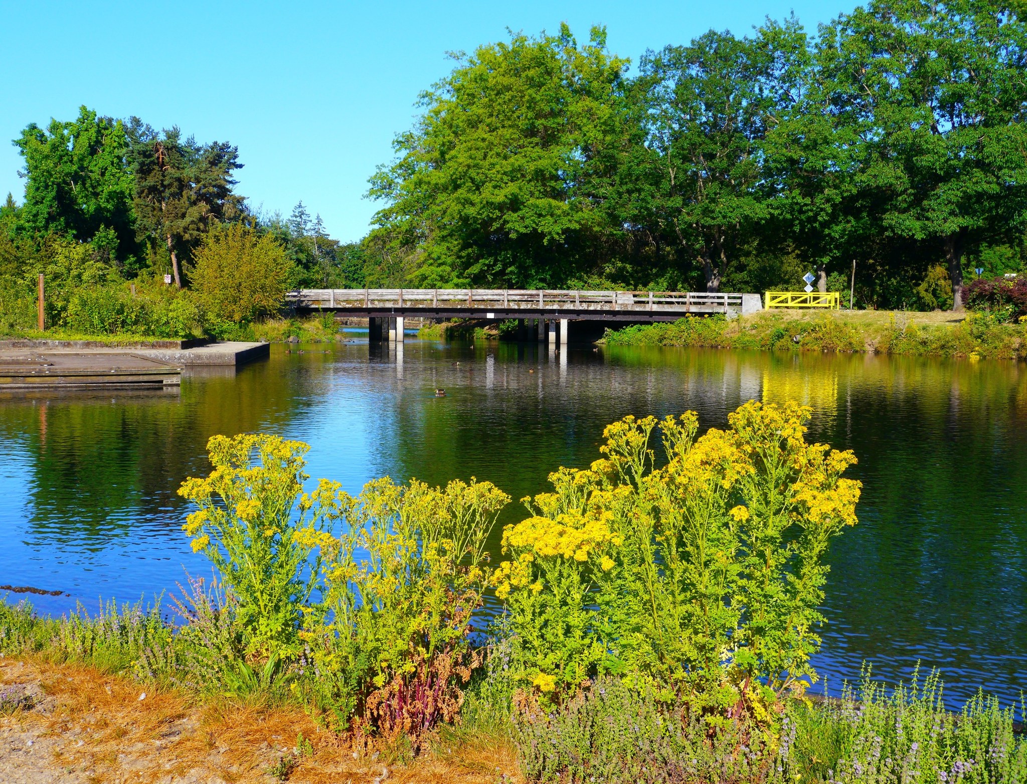
Duck pond and footbridge in Alton Baker Park, Eugene, Oregon.

Outdoors

Hiking near Eugene

National forests, parks, lakes and recreation areas with hiking trails near Eugene, closest first.

23places to hike
5 mito the closest
21within 30 miles
September–Junebest months

Good to know: Carry more water than you think you need, check the managing agency’s page for trail closures and fire restrictions, and start early on hot days.

Closest picks

1

West Eugene Wetlands

5 mi west · Bureau of Land Management

On the western edge of the City of Eugene, visitors can view wildlife and restored wetlands while they walk trails, play a round of disc golf, or ride the Fern Ridge Bicycle Path through the wetlands.

2

Fern Ridge Lake

11 mi northwest · US Army Corps of Engineers

Fern Ridge Lake, a popular recreation area for sailing, power boating and water skiing, is just 12 miles from downtown Eugene.

3

Dexter Lake

16 mi southeast · US Army Corps of Engineers

22 miles southeast of Eugene, Dexter Lake is a popular recreation area offering year-round fishing, seasonal water skiing, sailing, swimming, picnicking and hunting.

Map of all 23 places

Map of 23 places loads as you scroll.

Within 30 miles (21)

5 mi west · Bureau of Land Management

West Eugene Wetlands

On the western edge of the City of Eugene, visitors can view wildlife and restored wetlands while they walk trails, play a round of disc golf, or ride the Fern Ridge Bicycle Path through the wetlands.

  • Biking
  • Disc Golf
  • Dogs On Leash (Leash Required)
  • Hiking
  • Photography
  • Picnicking
  • Ranger programs
  • Wildlife viewing

11 mi northwest · US Army Corps of Engineers

Fern Ridge Lake

Fern Ridge Lake, a popular recreation area for sailing, power boating and water skiing, is just 12 miles from downtown Eugene.

  • Boating
  • Camping
  • Fishing
  • Hiking
  • Picnicking
  • Water sports
  • Wildlife viewing

16 mi southeast · US Army Corps of Engineers

Dexter Lake

22 miles southeast of Eugene, Dexter Lake is a popular recreation area offering year-round fishing, seasonal water skiing, sailing, swimming, picnicking and hunting.

  • Boating
  • Hiking
  • Picnicking
  • Water sports
  • Wildlife viewing

17 mi northeast · Bureau of Land Management

Shotgun Creek OHV Staging Area

Looking for that motorized trail experience to enjoy with family and friends? The Shotgun OHV System offers a mix of challenges, scenic views, technical features, and amenities to satisfy the OHV enthusiast.

  • Fishing
  • Hiking
  • Horseback riding
  • Off-highway vehicles
  • Photography
  • Picnicking
  • Recreational Vehicles
  • Swimming

17 mi northeast · Bureau of Land Management · Campground

Shotgun Creek Recreation Site

The refreshing location with its lush, forest setting, coupled with comforts normally associated with an urban park, blend seamlessly at this popular day-use site.

  • Birding
  • Camping
  • Hiking
  • Picnicking
  • Swimming

18 mi southwest · Bureau of Land Management

Carpenter Bypass Trail System

Whether you rock your lycra loud and proud, don moldy flannel, or track frequent flier miles, you are bound to find stuff to post on your favorite social media account at this popular trail system.

  • Biking
  • Hiking
  • Horseback riding
  • Photography
  • Picnicking

18 mi southeast · US Army Corps of Engineers

Fall Creek Lake

This scenic 1,852 acre lake is surrounded by 22 miles of forested shoreline, providing many opportunities for outdoor recreation such as boating, water skiing, hiking and wildlife viewing.

  • Boating
  • Hiking
  • Hotel/Lodge/Resort Privately Owned
  • Picnicking
  • Water sports
  • Wildlife viewing

19 mi southeast · US Army Corps of Engineers

Lookout Point Lake

22 miles southeast of Eugene, Lookout Point Lake is a popular recreation area offering year-round fishing, seasonal water skiing, sailing, swimming, picnicking and hunting.

  • Boating
  • Hiking
  • Picnicking
  • Water sports
  • Wildlife viewing

19 mi south · Bureau of Land Management

Row River Trail

This 14-mile, paved, multi-use National Recreation Trail follows the route of the now-abandoned Oregon Pacific & Eastern Railroad line, along the scenic shores of the Row (rhymes with "cow") River and Dorena Reservoir.

  • Biking
  • Boating
  • Camping
  • Fishing
  • Hiking
  • History
  • Horseback riding
  • Photography

20 mi south · US Army Corps of Engineers

Dorena Lake

The lake is located in rolling, partially wooded hill country. Its three parks offer boating, swimming, sailing, fishing and water skiing. Schwarz park located downstream of the dam, offers overnight camping for families and groups.

  • Biking
  • Boating
  • Fishing
  • Hiking
  • Nature education
  • Picnicking
  • Water sports
  • Wildlife viewing

23 mi south · US Army Corps of Engineers

Cottage Grove Lake

The lake and its shoreline set in the gently rolling hills of the Willamette Valley, is used for boating, swimming, water skiing, fishing, picnicking and camping.

  • Boating
  • Fishing
  • Hiking
  • Nature education
  • Picnicking
  • Water sports
  • Wildlife viewing

24 mi northwest · Bureau of Land Management

Hult Dam & Reservoir

This site, sometimes referred to as Horton Lake, Hult Marsh, Hult Reservoir, or Mill Pond, was developed in the early 1900s for logging operations.

  • Boating
  • Camping
  • Fishing
  • Hiking
  • Horseback riding
  • Picnicking

24 mi southeast · US Army Corps of Engineers · Campground

Ivan Oakes Campground

Ivan Oakes Campground is located on Lookout Point Lake in Oregon's Willamette Valley. Recreation Ivan Oakes Campground is located on the northern shore of Lookout Point Lake in the Calapooya Mountains.

  • Biking
  • Camping
  • Hiking
  • Water sports

25 mi west · Bureau of Land Management

Lower Lake Creek Falls

The natural bedrock slide at Lake Creek Falls is very popular and ideal for a hot summer day! A series of low cascades carved in the bedrock within a narrow gorge create this geological wonder that spills into Triangle Lake.

  • Biking
  • Boating
  • Camping
  • Climbing
  • Diving
  • Fishing
  • Hiking
  • Hunting

26 mi east · USDA Forest Service · Campground

Clark Creek Organization Camp

Clark Creek, located 12 miles northeast of Lowell, Oregon, is a fantastic group campground built by the Civilian Conservation Corps.

  • Biking
  • Camping
  • Hiking

27 mi northwest · Bureau of Land Management · Campground

Alsea Falls Recreation Site (Campground)

Reserve a site at Alsea Falls on recreation.gov or pay when you arrive for non-reserved campsites using the Recreation.gov Mobile App . You must download before you reach the site since there is no cell reception in the drainage.

  • Biking
  • Camping
  • Fishing
  • Hiking
  • Hunting
  • Mountain Biking
  • Photography

27 mi west · Bureau of Land Management

Siuslaw River SRMA

We are working towards adding this recreation site to recreation.gov for electronic payment options with the Recreation.gov Mobile App that you must download before you reach the site.

  • Camping
  • Hiking
  • Water Access

27 mi northwest · Fish and Wildlife Service

William L. Finley National Wildlife Refuge

Located outside the City of Corvallis, just off of Highway 99, William L. Finley offers unique wildlife viewing opportunities for the whole family!

  • Birding
  • Educational Programs
  • Fishing
  • Hiking
  • Hunting
  • Photography
  • Ranger programs
  • Wildlife viewing

29 mi west · Bureau of Land Management

Old Growth Ridge National Recreation Trail

Beginning in the Whittaker Creek Campground, the steep Old Growth Ridge Trail ascends 750 vertical feet over a mile’s length, topping out at a peekaboo viewpoint over the Siuslaw River.

  • Hiking
  • Photography

29 mi southeast · USDA Forest Service · Campground

Rujada Campground

Rujada Campground is located 21 miles east of Cottage Grove (45 minutes from Eugene) on a riverside terrace above Layng Creek.

  • Camping
  • Fishing
  • Hiking
  • Swimming

29 mi southeast · USDA Forest Service · Campground

Rujada Day Use Picnic Area

Rujada Day Use Picnic Area is set along the banks of Layng Creek, with a large, open grassy area amidst a scattering of Douglas fir. Rujada is a perfect setting for family reunions, parties or group getaways.

  • Camping
  • Hiking
  • Swimming

30 to 75 miles (2)

32 mi northeast · US Army Corps of Engineers

Foster Lake

Located in the beautiful Willamette Valley on the South Santiam River, Foster Lake provides boating, swimming and picnicking opportunities. The Foster Dam and Lake regulates the flow from the nearby Green Peter dam.

  • Boating
  • Camping
  • Fishing
  • Hiking
  • Picnicking
  • Water sports
  • Wildlife viewing

39 mi northeast · US Army Corps of Engineers

Green Peter Lake

Located in the beautiful Willamette Valley on the Middle Santiam River, Green Peter Lake provides boating, swimming and picnicking opportunities.

  • Boating
  • Hiking
  • Picnicking
  • Water sports
  • Wildlife viewing

Distances are straight-line miles from downtown Eugene. Listings come from Recreation.gov’s federal recreation database; check each official page for hours, fees, fire restrictions and closures before you go.

Get outside around Eugene

6 things you have to do when you visit Eugene, Oregon! video thumbnail

THINGS TO DO · YOUTUBE SHORT

6 things you have to do when you visit Eugene, Oregon!

An activity Short shared by Traveling Spud.

Watch on YouTube ↗

Around Eugene

Urban Garden (Eugene, Oregon)
Urban Garden (Eugene, Oregon)Visitor7 · CC BY-SA 3.0
Eugene Springfield aerial
Eugene Springfield aerial 01Kingofthedead · CC BY-SA 4.0
Eugene Saturday Market
Eugene Saturday Market (4)Tamanoeconomico · CC BY-SA 4.0

More outdoors near Eugene

Questions

Where is the closest place for hiking near Eugene?

West Eugene Wetlands (Bureau of Land Management), about 5 miles west of Eugene as the crow flies. Next are Fern Ridge Lake (11 mi) and Dexter Lake (16 mi).

When is the best time for hiking near Eugene?

Based on Eugene’s average highs, September–June. Conditions at higher elevations can be much cooler.

Who manages these places?

Federal agencies including Bureau of Land Management, US Army Corps of Engineers, USDA Forest Service. Each listing links to its official page for hours, fees, closures and current conditions.

Eugene AI

Your Eugene local guide
Hey there!

I'm Eugene AI. Ask about local food, shopping, history or a day out.

AI recommendations may be inaccurate. Verify hours and prices. Questions are processed by Cloudflare. Privacy