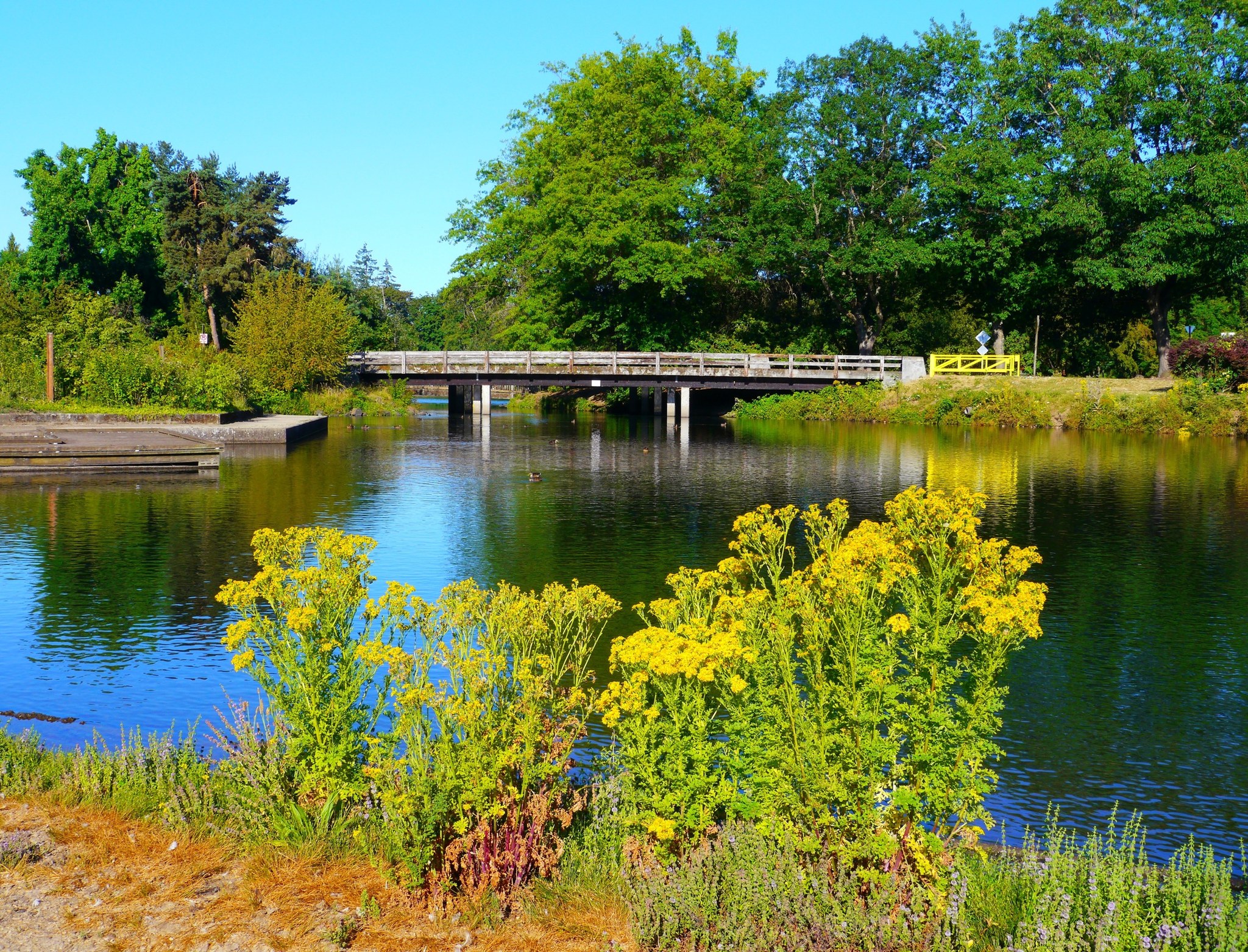
Duck pond and footbridge in Alton Baker Park, Eugene, Oregon.

Outdoors

Biking and mountain biking near Eugene

Trails and recreation areas near Eugene open to biking and mountain biking.

10places to ride
5 mito the closest
10within 30 miles
Year-roundbest months

Good to know: Wilderness areas are closed to bikes; check each area’s trail rules and yield to hikers and horses.

Closest picks

1

West Eugene Wetlands

5 mi west · Bureau of Land Management

On the western edge of the City of Eugene, visitors can view wildlife and restored wetlands while they walk trails, play a round of disc golf, or ride the Fern Ridge Bicycle Path through the wetlands.

2

Carpenter Bypass Trail System

18 mi southwest · Bureau of Land Management

Whether you rock your lycra loud and proud, don moldy flannel, or track frequent flier miles, you are bound to find stuff to post on your favorite social media account at this popular trail system.

3

Row River Trail

19 mi south · Bureau of Land Management

This 14-mile, paved, multi-use National Recreation Trail follows the route of the now-abandoned Oregon Pacific & Eastern Railroad line, along the scenic shores of the Row (rhymes with "cow") River and Dorena Reservoir.

Map of all 10 places

Map of 10 places loads as you scroll.

Within 30 miles (10)

5 mi west · Bureau of Land Management

West Eugene Wetlands

On the western edge of the City of Eugene, visitors can view wildlife and restored wetlands while they walk trails, play a round of disc golf, or ride the Fern Ridge Bicycle Path through the wetlands.

  • Biking
  • Disc Golf
  • Dogs On Leash (Leash Required)
  • Hiking
  • Photography
  • Picnicking
  • Ranger programs
  • Wildlife viewing

18 mi southwest · Bureau of Land Management

Carpenter Bypass Trail System

Whether you rock your lycra loud and proud, don moldy flannel, or track frequent flier miles, you are bound to find stuff to post on your favorite social media account at this popular trail system.

  • Biking
  • Hiking
  • Horseback riding
  • Photography
  • Picnicking

19 mi south · Bureau of Land Management

Row River Trail

This 14-mile, paved, multi-use National Recreation Trail follows the route of the now-abandoned Oregon Pacific & Eastern Railroad line, along the scenic shores of the Row (rhymes with "cow") River and Dorena Reservoir.

  • Biking
  • Boating
  • Camping
  • Fishing
  • Hiking
  • History
  • Horseback riding
  • Photography

19 mi south · US Army Corps of Engineers · Campground

Schwarz Park

Schwarz Campground is located below Dorena Lake in Oregon's Southern Willamette Valley. The campground is approximately five miles from the city of Cottage Grove.

  • Biking
  • Boating
  • Camping
  • Fishing
  • History
  • Water sports

20 mi south · US Army Corps of Engineers

Dorena Lake

The lake is located in rolling, partially wooded hill country. Its three parks offer boating, swimming, sailing, fishing and water skiing. Schwarz park located downstream of the dam, offers overnight camping for families and groups.

  • Biking
  • Boating
  • Fishing
  • Hiking
  • Nature education
  • Picnicking
  • Water sports
  • Wildlife viewing

24 mi southeast · US Army Corps of Engineers · Campground

Ivan Oakes Campground

Ivan Oakes Campground is located on Lookout Point Lake in Oregon's Willamette Valley. Recreation Ivan Oakes Campground is located on the northern shore of Lookout Point Lake in the Calapooya Mountains.

  • Biking
  • Camping
  • Hiking
  • Water sports

25 mi west · Bureau of Land Management

Lower Lake Creek Falls

The natural bedrock slide at Lake Creek Falls is very popular and ideal for a hot summer day! A series of low cascades carved in the bedrock within a narrow gorge create this geological wonder that spills into Triangle Lake.

  • Biking
  • Boating
  • Camping
  • Climbing
  • Diving
  • Fishing
  • Hiking
  • Hunting

26 mi east · USDA Forest Service · Campground

Clark Creek Organization Camp

Clark Creek, located 12 miles northeast of Lowell, Oregon, is a fantastic group campground built by the Civilian Conservation Corps.

  • Biking
  • Camping
  • Hiking

27 mi northwest · Bureau of Land Management · Campground

Alsea Falls Recreation Site (Campground)

Reserve a site at Alsea Falls on recreation.gov or pay when you arrive for non-reserved campsites using the Recreation.gov Mobile App . You must download before you reach the site since there is no cell reception in the drainage.

  • Biking
  • Camping
  • Fishing
  • Hiking
  • Hunting
  • Mountain Biking
  • Photography

30 mi southeast · USDA Forest Service · Campground

Black Canyon Campground (Willamette National Forest, OR)

Black Canyon Campground in Oregon rests next to the Middle Fork of the Willamette River. This scenic campground is heavily shaded by towering hemlock, cedar and Douglas fir. Fishing and kayaking are a popular pastimes.

  • Biking
  • Boating
  • Camping
  • Fishing
  • Kayaking

Distances are straight-line miles from downtown Eugene. Listings come from Recreation.gov’s federal recreation database; check each official page for hours, fees, fire restrictions and closures before you go.

Get outside around Eugene

6 things you have to do when you visit Eugene, Oregon! video thumbnail

THINGS TO DO · YOUTUBE SHORT

6 things you have to do when you visit Eugene, Oregon!

An activity Short shared by Traveling Spud.

Watch on YouTube ↗

Around Eugene

Entrance sign for the Eugene Masonic Cemetery
Entrance sign for the Eugene Masonic CemeteryRick Obst · CC BY 2.0
Art in Eugene
Art in Eugene (7967026300)Robert Ashworth from Bellingham, WA., USA · CC BY 2.0
South Hills, Eugene, OR 97405, USA - iamlnm
South Hills, Eugene, OR 97405, USA - iamlnm (2)iamlnm · CC BY-SA 3.0

More outdoors near Eugene

Questions

Where is the closest place for biking near Eugene?

West Eugene Wetlands (Bureau of Land Management), about 5 miles west of Eugene as the crow flies. Next are Carpenter Bypass Trail System (18 mi) and Row River Trail (19 mi).

When is the best time for biking near Eugene?

Based on Eugene’s average highs, all year. Conditions at higher elevations can be much cooler.

Who manages these places?

Federal agencies including Bureau of Land Management, US Army Corps of Engineers, USDA Forest Service. Each listing links to its official page for hours, fees, closures and current conditions.

Eugene AI

Your Eugene local guide
Hey there!

I'm Eugene AI. Ask about local food, shopping, history or a day out.

AI recommendations may be inaccurate. Verify hours and prices. Questions are processed by Cloudflare. Privacy